Difference between revisions of "Map B.01 - Lofoten"
Tao alexis (talk | contribs) |
Tao alexis (talk | contribs) |
||
| Line 4: | Line 4: | ||
== Land == | == Land == | ||
| − | The map depicts the whole of [[Nanbrun]], with parts of [[Breen]] ([[Moreland]]), [[Denmark & Norway]] ([[Nordland]], [[Nor-Trondelag]], [[Sor-Trondelag]], [[Troms]]), [[Sweden]] ([[Angermanland]]), [[Ulthua]] ([[Finnemar]], [[Laponia]]) and [[Vastenjaur]] ([[ | + | The map depicts the whole of [[Thane of Nanbrun|Nanbrun]], with parts of [[Breen]] ([[Moreland]]), [[Kingdom of Denmark & Norway|Norway]] ([[County of Nordland|Nordland]], [[County of Nor-Trondelag|Nor-Trondelag]], [[County of Sor-Trondlag|Sor-Trondelag]], [[County of Troms|Troms]]), [[Kingdom of Sweden|Sweden]] ([[County of Angermanland|Angermanland]]), [[Principality of Ulthua|Ulthua]] ([[Thann of Finnemar|Finnemar]], [[Thann of Laponia|Laponia]]) and [[Kingdom of Vastenjaur|Vastenjaur]] ([[Earldom of Fieldland|Fieldland]], [[Earldom of Knollslan|Knollslan]]). The map is named after the [https://en.wikipedia.org/wiki/Lofoten Lofoten Islands] located on the coast of Nordland. |
== Peoples == | == Peoples == | ||
Revision as of 05:24, 21 August 2020
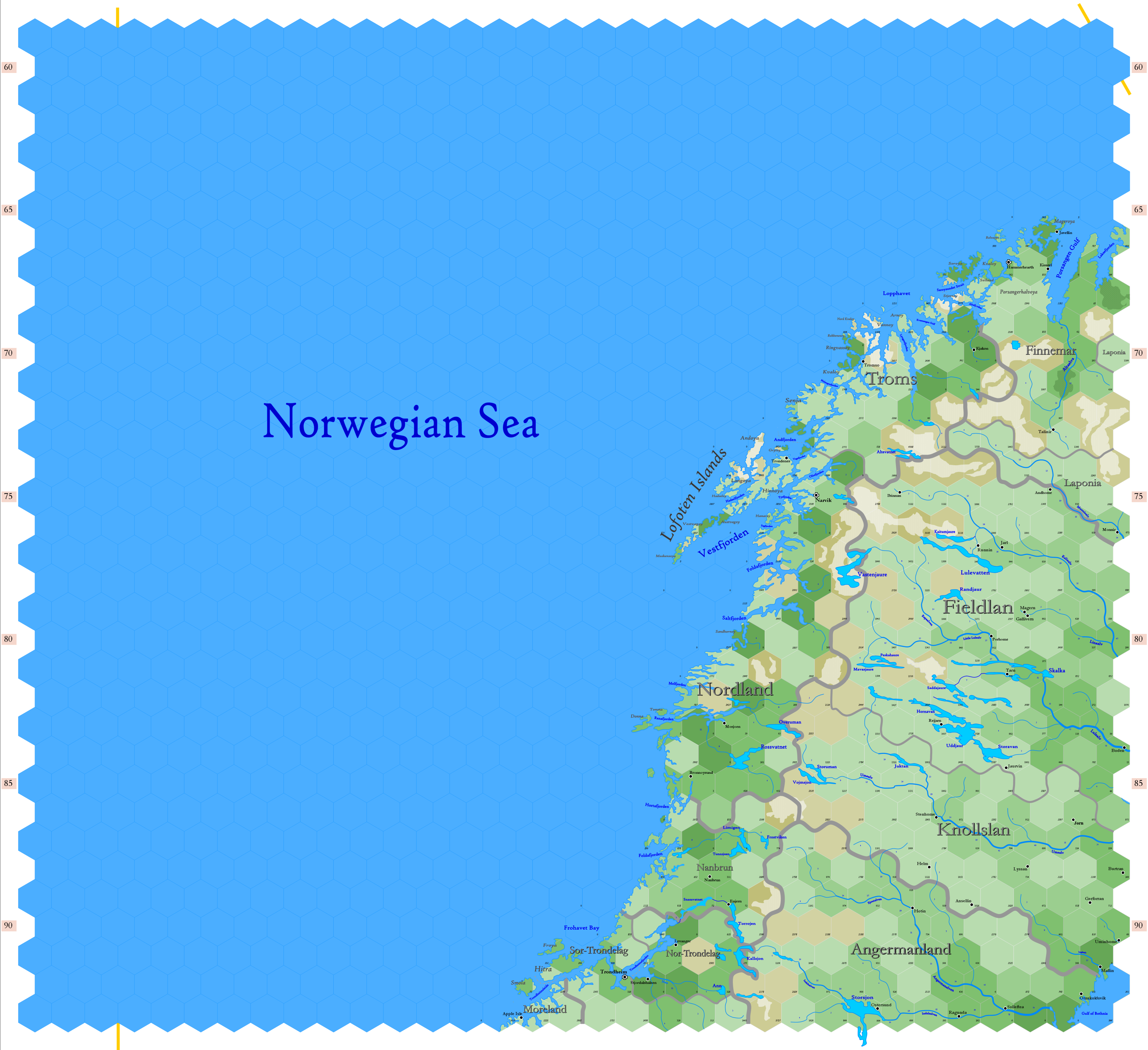
Click to enlarge. Shows latitude 62.96° to 72.50° north; shows longitude at bottom of map between 1.94°W and 19.34°E. The orange line on the left of the map indicates 0° Greenwich; the orange line at the upper right indicates 30°E. Hexes are 20 miles in diameter. Numbers on the left and right indicate distance from the North Pole in hexes.
Land
The map depicts the whole of Nanbrun, with parts of Breen (Moreland), Norway (Nordland, Nor-Trondelag, Sor-Trondelag, Troms), Sweden (Angermanland), Ulthua (Finnemar, Laponia) and Vastenjaur (Fieldland, Knollslan). The map is named after the Lofoten Islands located on the coast of Nordland.
Peoples
The map includes gnomish populations in Fieldlan, Knollslan and Nanbrun; a halfling population in Moreland; an elvish population in Finnemar and Laponia; and human populations in Angermanland, Nordland, Nor-Trondelag, Sor-Trondelag and Troms. Despite the mix in populations, these peoples have learned to live together in relative harmony. The humans are the most recent newcomers, having settled the Norwegian Sea coast some 800 to 1000 years ago.
See Also,
Sheet Maps
- East: Lapland
- NEast: Greenland Sea
- NWest: High Greenland
- West: Iceland
And from Wikipedia:
