Difference between revisions of "Map A.05 - Yukaghir Sea"
Tao alexis (talk | contribs) |
Tao alexis (talk | contribs) |
||
| Line 1: | Line 1: | ||
[[File:A.05 - Yukaghir Sea.jpg|right|680px|thumb]] | [[File:A.05 - Yukaghir Sea.jpg|right|680px|thumb]] | ||
| − | '''Incomplete Map'''. Arctic region reaching from 82.34°N south to 72.51°N, utterly undiscovered by civilisation. Includes the eastern portion of the Samoyad Peninsula and the northern coastline of [[March of Sakha|Sakha]], part of [[Empire of Trakkatch Dran|Trakkatch Dran]], a vast land under the suzerainty of the norker people. | + | '''Incomplete Map'''. Arctic region reaching from 82.34°N south to 72.51°N, utterly undiscovered by civilisation. Includes the eastern portion of the Samoyad Peninsula and the northern coastline of [[March of Sakha|Sakha]], part of [[Empire of Trakkatch Dran|Trakkatch Dran]], a vast land under the suzerainty of the norker people. The unmapped Islands of Aryania skirt the eastern edge of the map. |
Hexes are [[20-mile Hex Map|20 miles]] in diameter. Total area depicted equals 366,450 sq.m. | Hexes are [[20-mile Hex Map|20 miles]] in diameter. Total area depicted equals 366,450 sq.m. | ||
| Line 21: | Line 21: | ||
{| class="wikitable" style="text-align: center; background-color:#d4f2f2;" | {| class="wikitable" style="text-align: center; background-color:#d4f2f2;" | ||
|- | |- | ||
| − | ! [[Map A.04 - Kara Sea|A4: Kara Sea]] !! colspan="2"|[[Map A.05 - Yukaghir Sea|A5: Yukaghir Sea]] !! [[Map A.06 - | + | ! [[Map A.04 - Kara Sea|A4: Kara Sea]] !! colspan="2"|[[Map A.05 - Yukaghir Sea|A5: Yukaghir Sea]] !! [[Map A.06 - Aryania|A6: Aryania]] |
|- | |- | ||
! colspan="2"|[[Map B.06 - Tunguska|B6: Tunguska]] !! colspan="2"|[[Map B.07 - Verkhoy Range|B7: Verkhoy Range]] | ! colspan="2"|[[Map B.06 - Tunguska|B6: Tunguska]] !! colspan="2"|[[Map B.07 - Verkhoy Range|B7: Verkhoy Range]] | ||
Revision as of 18:36, 2 July 2021
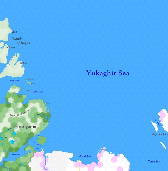
Incomplete Map. Arctic region reaching from 82.34°N south to 72.51°N, utterly undiscovered by civilisation. Includes the eastern portion of the Samoyad Peninsula and the northern coastline of Sakha, part of Trakkatch Dran, a vast land under the suzerainty of the norker people. The unmapped Islands of Aryania skirt the eastern edge of the map.
Hexes are 20 miles in diameter. Total area depicted equals 366,450 sq.m.
Contents
Features
Islands of Buyan
Mythical lands have never been viewed by Europeans; even the inhabitants of the mainland are hardly aware of their existence. According to legend, the Buyan Islands are able to appear and disappear. Three brothers, demi-gods of the northern, western and eastern winds, dwell here. The three largest islands, Bolshe, Nauk and Oktyab, are named for them. The Zoryas, solar demi-goddesses who are the daughters of the solar god Dazhbog, also dwell here.
Pronchis Mountains
An eastern extension of the Byranga Plateau, a mountain knot comprising foothills above a thousand feet and peaks ranging up to 3,000 ft.
Yukaghir Sea
An arm of the Arctic Ocean extending eastward from the Islands of Buyan
Provinces
Samoyadia
The Kingdom of Samoyadia is a gnoll realm and homeland of the gnoll people, in the furthest north of Siberia. Temperature ranges from very cold in the winter to chilly in July. The population is largely gnoll in race, but some norker clans can be found along the border with Sakha. Fauna includes reindeer, wolves, polar bears, ermine and migratory birds; transhumance is practiced among copious reindeer herds that move to foothills of the Pronchis Mountains in summer and southwestward in the winter. The immense kingdom has an area of 730.7 hexes and a population of 15,625.
Adjacent Maps
| A4: Kara Sea | A5: Yukaghir Sea | A6: Aryania | |
|---|---|---|---|
| B6: Tunguska | B7: Verkhoy Range | ||
See Sheet Maps
