Difference between revisions of "Map A.04 - Kara Sea"
Tao alexis (talk | contribs) |
Tao alexis (talk | contribs) |
||
| Line 7: | Line 7: | ||
Trade is largely non-existent. The Yenisey Gulf is a passage into the interior. In warm years, whaling ships will sometimes venture into the Kara Sea in August-September, rarely reaching as far east as the Tallya Gulf. Apart from these brief periods, all water showing on the map is frozen for 9-10 months of the year. The region is well-known for its vast herds of mammoths and mastodon. | Trade is largely non-existent. The Yenisey Gulf is a passage into the interior. In warm years, whaling ships will sometimes venture into the Kara Sea in August-September, rarely reaching as far east as the Tallya Gulf. Apart from these brief periods, all water showing on the map is frozen for 9-10 months of the year. The region is well-known for its vast herds of mammoths and mastodon. | ||
| − | The orange line, showing at the center bottom and top right, gives the line of hexes that indicates 90°E. Numbers at the right indicate distance from the north pole in hexes; the direction of north is at the top right, so it must be noted the direction on the map turns 60° at the 90th meridian. | + | The orange line, showing at the center bottom and top right, gives the line of hexes that indicates 90°E. Numbers at the right indicate distance from the north pole in hexes; the direction of north is at the top right, so it must be noted the direction on the map turns 60° at the 90th meridian. Hexes are [[20-mile Hex Map|20 miles]] in diameter. |
<br> | <br> | ||
<br> | <br> | ||
Revision as of 03:10, 9 March 2020
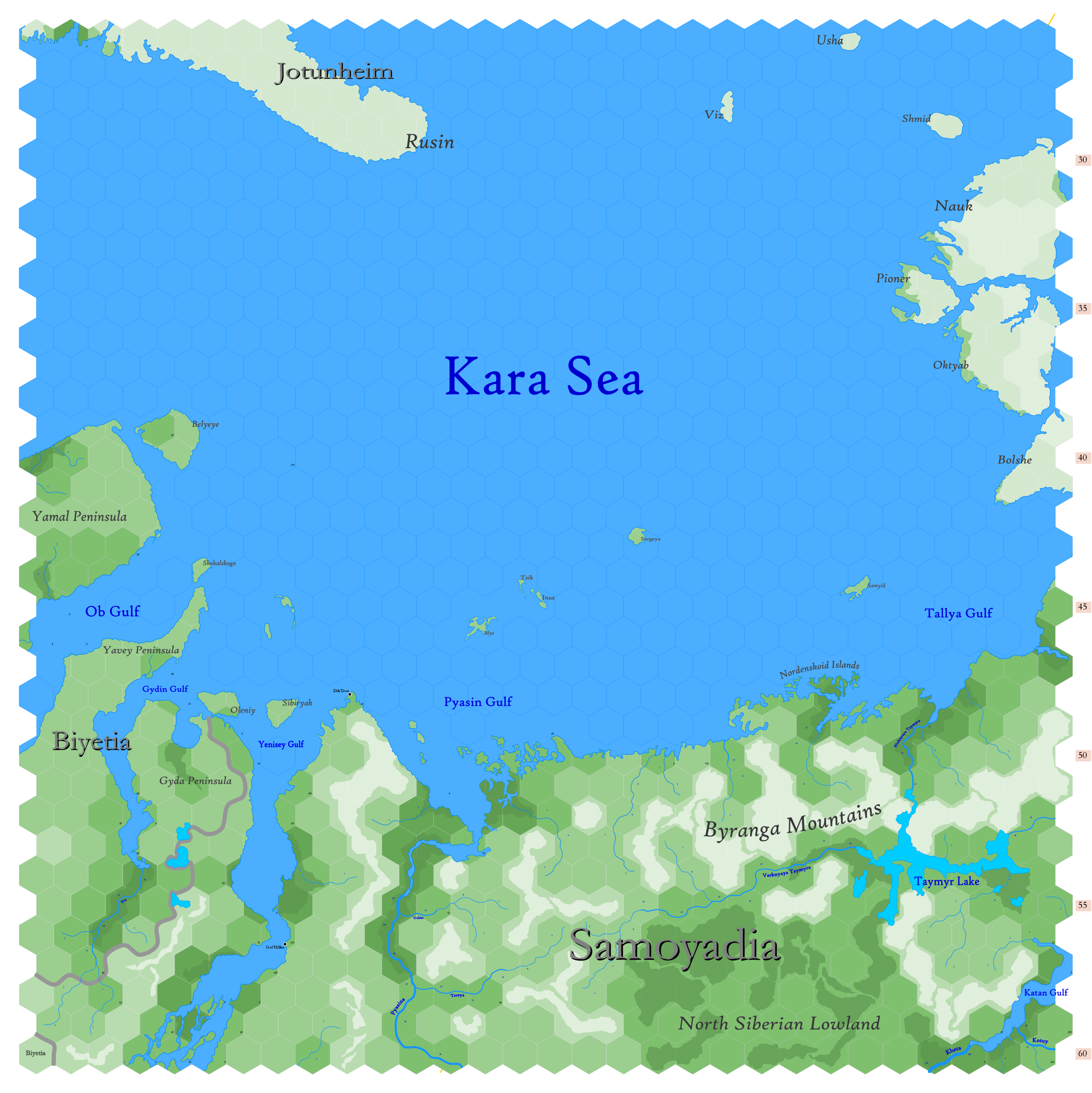
Click to enlarge. Shows latitude 72.51 to 82.34 north, including the northern reaches of Biyetia and Samoyadia, the northern tip of Jotunheim (the land of frost giants) and the great frozen islands of Hyperborea, bounded by the wide Kara Sea. These are lands that have been reinvented for my game world. The obscurity of these lands in the 17th century allows me to settle them with goblins (Biyetia) and gnolls (Samoyadia). The denizens of Aryans are unknown. Chances are, no party I ever run will have reason to go there.
Given the high latitudes and fierce weather of these lands, habitation is scant. Even the creatures native to these lands must struggle hard to survive. Even though the highlands are little more than a thousand feet above sea level, this makes them bitterly cold throughout the year. All is frozen much of the year. Lowlands are thick, impassable muskeg swamps in the summer and early fall, before freezing again. Most of what's shown is tundra; thin taiga forest can be found on the southern shores of the Yenisey Gulf (the long estuary of the Yenisey River on the west) and in the North Siberian Lowland.
Trade is largely non-existent. The Yenisey Gulf is a passage into the interior. In warm years, whaling ships will sometimes venture into the Kara Sea in August-September, rarely reaching as far east as the Tallya Gulf. Apart from these brief periods, all water showing on the map is frozen for 9-10 months of the year. The region is well-known for its vast herds of mammoths and mastodon.
The orange line, showing at the center bottom and top right, gives the line of hexes that indicates 90°E. Numbers at the right indicate distance from the north pole in hexes; the direction of north is at the top right, so it must be noted the direction on the map turns 60° at the 90th meridian. Hexes are 20 miles in diameter.
See Also,
Sheet Maps
- East: Laptev Sea
- West: Jotunheim
And from Wikipedia,
