Difference between revisions of "Map A.10 - Bathurst"
Tao alexis (talk | contribs) |
Tao alexis (talk | contribs) |
||
| Line 1: | Line 1: | ||
| − | [[File:A.10 - Bathurst. | + | [[File:A.10 - Bathurst.jpg|680px|thumb]] |
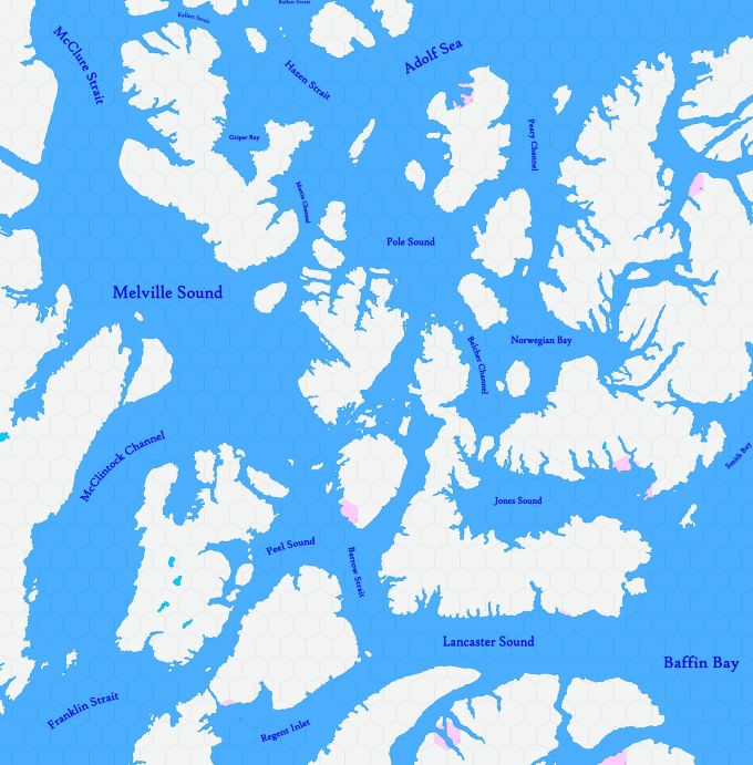
Click to enlarge. Shows latitude 72.51 to 82.34 north, including islands from the Canadian [https://en.wikipedia.org/wiki/Arctic_Archipelago Arctic Archipelago], including [https://en.wikipedia.org/wiki/Melville_Island_(Northwest_Territories_and_Nunavut) Melville], [https://en.wikipedia.org/wiki/Prince_of_Wales_Island_(Nunavut) Prince of Wales], [https://en.wikipedia.org/wiki/Somerset_Island_(Nunavut) Somerset], [https://en.wikipedia.org/wiki/Bathurst_Island_(Canada) Bathurst], [https://en.wikipedia.org/wiki/Devon_Island Devon] and [https://en.wikipedia.org/wiki/Axel_Heiberg_Island Axel Heiberg] islands, with parts of [https://en.wikipedia.org/wiki/Banks_Island Banks], [https://en.wikipedia.org/wiki/Victoria_Island_(Canada) Victoria], [https://en.wikipedia.org/wiki/Baffin_Island Baffin] and [https://en.wikipedia.org/wiki/Ellesmere_Island Ellesmere] islands. Obviously, these names are from the 19th century and are a convenience at present, until such time as the map is completed. What's shown here is a map in progress, with some — but not all — of the coastlines plotted. | Click to enlarge. Shows latitude 72.51 to 82.34 north, including islands from the Canadian [https://en.wikipedia.org/wiki/Arctic_Archipelago Arctic Archipelago], including [https://en.wikipedia.org/wiki/Melville_Island_(Northwest_Territories_and_Nunavut) Melville], [https://en.wikipedia.org/wiki/Prince_of_Wales_Island_(Nunavut) Prince of Wales], [https://en.wikipedia.org/wiki/Somerset_Island_(Nunavut) Somerset], [https://en.wikipedia.org/wiki/Bathurst_Island_(Canada) Bathurst], [https://en.wikipedia.org/wiki/Devon_Island Devon] and [https://en.wikipedia.org/wiki/Axel_Heiberg_Island Axel Heiberg] islands, with parts of [https://en.wikipedia.org/wiki/Banks_Island Banks], [https://en.wikipedia.org/wiki/Victoria_Island_(Canada) Victoria], [https://en.wikipedia.org/wiki/Baffin_Island Baffin] and [https://en.wikipedia.org/wiki/Ellesmere_Island Ellesmere] islands. Obviously, these names are from the 19th century and are a convenience at present, until such time as the map is completed. What's shown here is a map in progress, with some — but not all — of the coastlines plotted. | ||
Revision as of 01:12, 3 July 2021
Click to enlarge. Shows latitude 72.51 to 82.34 north, including islands from the Canadian Arctic Archipelago, including Melville, Prince of Wales, Somerset, Bathurst, Devon and Axel Heiberg islands, with parts of Banks, Victoria, Baffin and Ellesmere islands. Obviously, these names are from the 19th century and are a convenience at present, until such time as the map is completed. What's shown here is a map in progress, with some — but not all — of the coastlines plotted.
The region is conceivably reachable by a party in my game; I have some idea of what's dwelling here, but it would be unknown to European scholars. A journey here would require considerable resources and effort, not to mention years. I know something about the manner in which these islands were explored and the tenacity of the explorers for whom these straits and places were named.
The orange line, showing at the center bottom and top right, gives the line of hexes that indicates 90°W. Numbers at the right indicate distance from the north pole in hexes; the direction of north is at the top right, so it must be noted the direction on the map turns 60° at the 90th meridian. Hexes are 20 miles in diameter.
See Also,
Sheet Maps
- East: West Greenland
- West: Melville
