Difference between revisions of "Map A.01 - Greenland Sea"
Tao alexis (talk | contribs) |
Tao alexis (talk | contribs) |
||
| Line 1: | Line 1: | ||
[[File:A.01 - Greenland Sea.jpg|680px|thumb]] | [[File:A.01 - Greenland Sea.jpg|680px|thumb]] | ||
| − | + | '''Incomplete map'''. Arctic region reaching from 82.34°N south to 72.51°N, much of which has never been penetrated by civilised shipping beyond the southern tip of Spitsbergen, which has been seen but never explored. Details about its residents are unknown. | |
| − | + | Hexes are [[20-mile Hex Map|20 miles]] in diameter. Total area depicted equals 366,450 sq.m. | |
| + | |||
| + | == Features == | ||
| + | ==== Arctic Ocean ==== | ||
| + | An almost completely landlocked body of water surrounded by the continents of Europe, Asia and America. The map shown gives the best possible access to the ocean. The ocean is a vast waste of pack ice, formed during the autumn, winter and spring months. Glacial ice, the source of icebergs, orginate largely on Greenland. Icebergs, however, comprise only about one third of the ice content of the Arctic Ocean, and are found mainly in the Greenland Sea. None of the sea has been charted, and is unknown to civilisation. Known life includes seals, polar bears, whales, ice toads, remoraz and white puddings. | ||
| + | |||
| + | ==== Greenland Sea ==== | ||
| + | A part of the [[Atlantic Ocean]] and connects to the Arctic Ocean by the Fram Strait, between Greenland and Spitsbergen. A mythological ridge exists below the surface of the Fram Strait, one of the many places rumoured as the lair of the Great Leviathan. The shallowest depth of the sea is more than 300 fathoms. Polar ice fills this portion of the Greenland Sea most of the year, but it's exact position depends on the winds. In spring the outer edge of the pack ice follows a general line crossing the bottom of the map shown. In June and July the ice moves farther westward, with its breadth off the east coast of Greenland varying from year to year. | ||
| − | |||
| − | |||
See Also,<br> | See Also,<br> | ||
Revision as of 21:06, 1 July 2021
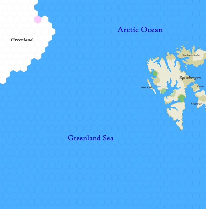
Incomplete map. Arctic region reaching from 82.34°N south to 72.51°N, much of which has never been penetrated by civilised shipping beyond the southern tip of Spitsbergen, which has been seen but never explored. Details about its residents are unknown.
Hexes are 20 miles in diameter. Total area depicted equals 366,450 sq.m.
Features
Arctic Ocean
An almost completely landlocked body of water surrounded by the continents of Europe, Asia and America. The map shown gives the best possible access to the ocean. The ocean is a vast waste of pack ice, formed during the autumn, winter and spring months. Glacial ice, the source of icebergs, orginate largely on Greenland. Icebergs, however, comprise only about one third of the ice content of the Arctic Ocean, and are found mainly in the Greenland Sea. None of the sea has been charted, and is unknown to civilisation. Known life includes seals, polar bears, whales, ice toads, remoraz and white puddings.
Greenland Sea
A part of the Atlantic Ocean and connects to the Arctic Ocean by the Fram Strait, between Greenland and Spitsbergen. A mythological ridge exists below the surface of the Fram Strait, one of the many places rumoured as the lair of the Great Leviathan. The shallowest depth of the sea is more than 300 fathoms. Polar ice fills this portion of the Greenland Sea most of the year, but it's exact position depends on the winds. In spring the outer edge of the pack ice follows a general line crossing the bottom of the map shown. In June and July the ice moves farther westward, with its breadth off the east coast of Greenland varying from year to year.
See Also,
Sheet Maps
- East: East Svalbard
- SEast: Lofoten
- SWest: Iceland
- West: High Greenland
