Difference between revisions of "6-mile Hex Map"
Tao alexis (talk | contribs) |
Tao alexis (talk | contribs) |
||
| Line 11: | Line 11: | ||
Once the infrastructure of a given 20-mile hex has been determined, and all of its surrounding hexes as well, it's possible to create a rectangular "section" of 6-mile hexes. This section includes two 20-mile hexes. Each 20-mile hex, everywhere in the world, is designated according to the latitude and longitude it represents. This enables us to locate that section on [https://earth.google.com/web/ GoogleEarth]. | Once the infrastructure of a given 20-mile hex has been determined, and all of its surrounding hexes as well, it's possible to create a rectangular "section" of 6-mile hexes. This section includes two 20-mile hexes. Each 20-mile hex, everywhere in the world, is designated according to the latitude and longitude it represents. This enables us to locate that section on [https://earth.google.com/web/ GoogleEarth]. | ||
| − | [[File:Falling Rain Elevation Data.png| | + | [[File:Falling Rain Elevation Data.png|left|420px|thumb]] |
The image on the right provides a cacophony of numbers that we use to identify which hex falls into which set of coordinates. These are organised by "rings," the number of hexes this particular line of hexes is from the North Pole (ring 1). In the image shown, "ring 143" indicates the North Pole is 142 x 20 miles away. The latitude of ring 143 is between 48.51 N and 48.79 N. The left-hand hex, containing the [[Settlement|settlement]] of Uman in Kiyev, has a longitude between 30.21 E and 30.62 E. The right-hand hex, in Vassia, has a longitude between 30.63 E and 31.04 E. | The image on the right provides a cacophony of numbers that we use to identify which hex falls into which set of coordinates. These are organised by "rings," the number of hexes this particular line of hexes is from the North Pole (ring 1). In the image shown, "ring 143" indicates the North Pole is 142 x 20 miles away. The latitude of ring 143 is between 48.51 N and 48.79 N. The left-hand hex, containing the [[Settlement|settlement]] of Uman in Kiyev, has a longitude between 30.21 E and 30.62 E. The right-hand hex, in Vassia, has a longitude between 30.63 E and 31.04 E. | ||
Revision as of 23:02, 13 December 2022
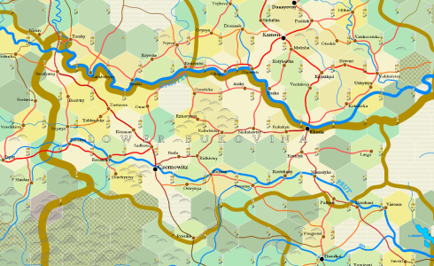
6-mile hex maps are zoomed-in maps derived from 20-mile hex maps, using a complex procedure of map drawing and random generation deriving from a map's infrastructure and real-world topography and place names.
Contents
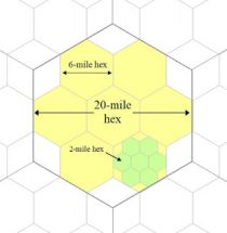
The designation "6-mile" is an inaccurate description. 6-mile hexes are derived from splitting a 20-mile hex, as shown in the image below, and are in fact 6.67 mi. in diameter, not six. Nonetheless, the "6-mile" appellation is used as a simplification.
Generation Procedure
Once the infrastructure of a given 20-mile hex has been determined, and all of its surrounding hexes as well, it's possible to create a rectangular "section" of 6-mile hexes. This section includes two 20-mile hexes. Each 20-mile hex, everywhere in the world, is designated according to the latitude and longitude it represents. This enables us to locate that section on GoogleEarth.
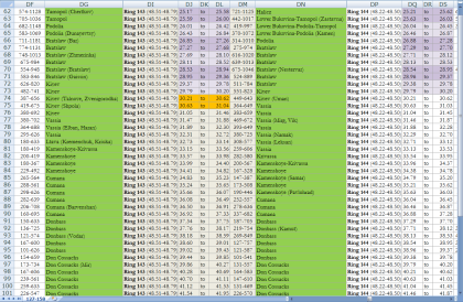
The image on the right provides a cacophony of numbers that we use to identify which hex falls into which set of coordinates. These are organised by "rings," the number of hexes this particular line of hexes is from the North Pole (ring 1). In the image shown, "ring 143" indicates the North Pole is 142 x 20 miles away. The latitude of ring 143 is between 48.51 N and 48.79 N. The left-hand hex, containing the settlement of Uman in Kiyev, has a longitude between 30.21 E and 30.62 E. The right-hand hex, in Vassia, has a longitude between 30.63 E and 31.04 E.


