Difference between revisions of "Map A.09 - Melville"
From The Authentic D&D Wiki
Jump to navigationJump to searchTao alexis (talk | contribs) |
Tao alexis (talk | contribs) |
||
| Line 1: | Line 1: | ||
| − | [[File:A.09 - Melville. | + | [[File:A.09 - Melville.jpg|right|680px|thumb]] |
| + | '''Incomplete map'''. Labels are a convenience until further design is applied. | ||
| − | + | Arctic region reaching from 82.34°N south to 72.51°N, including a vast frozen archipelago of hundreds of islands. Undiscovered by civilisation but according to legends, occupied by unknown human tribes. | |
| − | + | Hexes are [[20-mile Hex Map|20 miles]] in diameter. Total area depicted equals 366,450 sq.m. | |
| − | + | == Features == | |
| − | + | ==== Arctic Ocean ==== | |
| − | + | The '''Arctic Ocean''' is an almost completely landlocked body of water in the far north of the world. The ocean is a vast waste of pack ice, formed during the winter, spring and fall months. When the ice begins to break in early July, a relentless river of ice bergs move steadily eastward through the '''McClure Strait''', making westward passage impossible. In some years the '''Melville Sound''' is clear for shipping; in others, the sound is impassable. None of these waters have been discovered by civilisation. '''Melville Island''' is the largest of the islands north of the straight and east of '''Ellesmere''', on the map's eastern edge. A central plateau on Melville is inhabited by musk oxen. | |
| − | + | ||
| − | [[ | + | == Adjacent Maps == |
| − | + | {| class="wikitable" style="text-align: center; background-color:#d4f2f2;" | |
| − | : | + | |- |
| − | + | ! [[Map A.08 - Arctic|A8: Arctic]] !! colspan="2"|[[Map A.09 - Melville|A9: Melville]] !! [[Map A.10 - Bathurst|A10: Bathurst]] | |
| − | + | |- | |
| − | + | ! colspan="2"|[[Map B.12 - Yukon|B12: Yukon]] !! colspan="2"|[[Map B.13 - Barrens|B13: Barrens]] | |
| + | |} | ||
| + | |||
| + | |||
| + | See [[Sheet Maps]] | ||
Revision as of 01:09, 3 July 2021
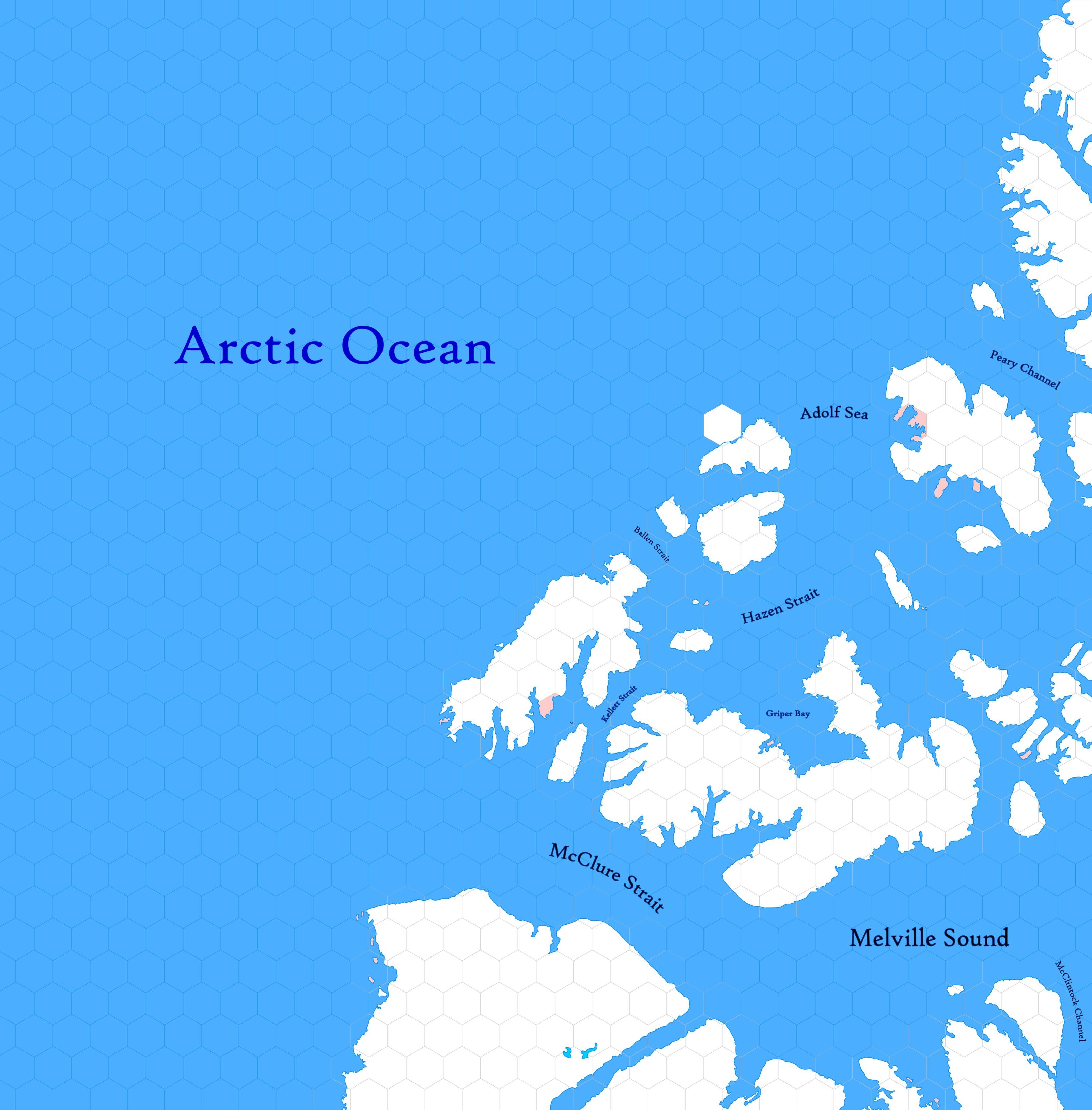
Incomplete map. Labels are a convenience until further design is applied.
Arctic region reaching from 82.34°N south to 72.51°N, including a vast frozen archipelago of hundreds of islands. Undiscovered by civilisation but according to legends, occupied by unknown human tribes.
Hexes are 20 miles in diameter. Total area depicted equals 366,450 sq.m.
Features
Arctic Ocean
The Arctic Ocean is an almost completely landlocked body of water in the far north of the world. The ocean is a vast waste of pack ice, formed during the winter, spring and fall months. When the ice begins to break in early July, a relentless river of ice bergs move steadily eastward through the McClure Strait, making westward passage impossible. In some years the Melville Sound is clear for shipping; in others, the sound is impassable. None of these waters have been discovered by civilisation. Melville Island is the largest of the islands north of the straight and east of Ellesmere, on the map's eastern edge. A central plateau on Melville is inhabited by musk oxen.
Adjacent Maps
| A8: Arctic | A9: Melville | A10: Bathurst | |
|---|---|---|---|
| B12: Yukon | B13: Barrens | ||
See Sheet Maps
