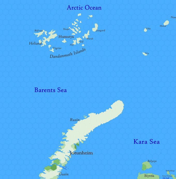
Map A.03 - Jotunheim
Arctic region reaching from 82.34°N south to 72.51°N. An obscure seafaring region, known only to a few civilised captains, whalers, who have dared venture this far into the Barents Sea. There is no sea route north of Rusin, the larger of two islands comprising the Realm of Jotunheim, for the Barents Sea is forever frozen; likewise, no ship can reach the Dandanmoth Islands, the presence of which is limited to myth. The only passage on the map between the Barents and the Kara seas is the Vimur River, a misnamed strait whose narrowest width is 660 yards. Most years, the strait remains frozen; access to the Kara is safest around the south end of Gusin Island, not shown on the map.
Also shown on the map is the northernmost tip of the Yamal Peninsula, extending north and south 430 miles. This land, and the Yavey Peninsula, are collectively a part of Biyetia.
Hexes are 20 miles in diameter. Total area depicted equals 366,450 sq.m.
Features
Arctic Ocean
An almost completely landlocked body of water inaccessible from anywhere on the map. That part shown has never been seen by civilisation; it is a vast waste of pack ice that remains in place the year round, though in summer months stretches of water, called leads, occur spontaneously in places and freeze again without warning.
Barents Sea
A portion of the Arctic Ocean, named after Willem Barents, who mapped part of the eastern sea in the 16th century while searching for the Northeast Passage to China. The greatest length of the Barents from east to west is 940 mi. Much of the sea is measurable, being less than 100 fathoms in depth. Eddies and currents are numerous and complex, requiring an expert navigator to safely venture here. Waters from the relatively warm North Atlantic Drift, a continuation of the Gulf Stream, enters from the Greenland Sea near Spitsbergen, raising the temperature of both water and air in that portion.
Although water temperatures vary in the eastern portion from year to year, they are coolest in April and warmest in September. The ice permanently covers the sea from Rusin Island in a line westward; the entire sea shown is frozen by December, except along the southern coast of Gusin, which usually freezes by March-April. During the summer, icebergs are common in all open water. Haddock, cod and plaice are plentiful and caught in large numbers.
