20-mile Hex Map
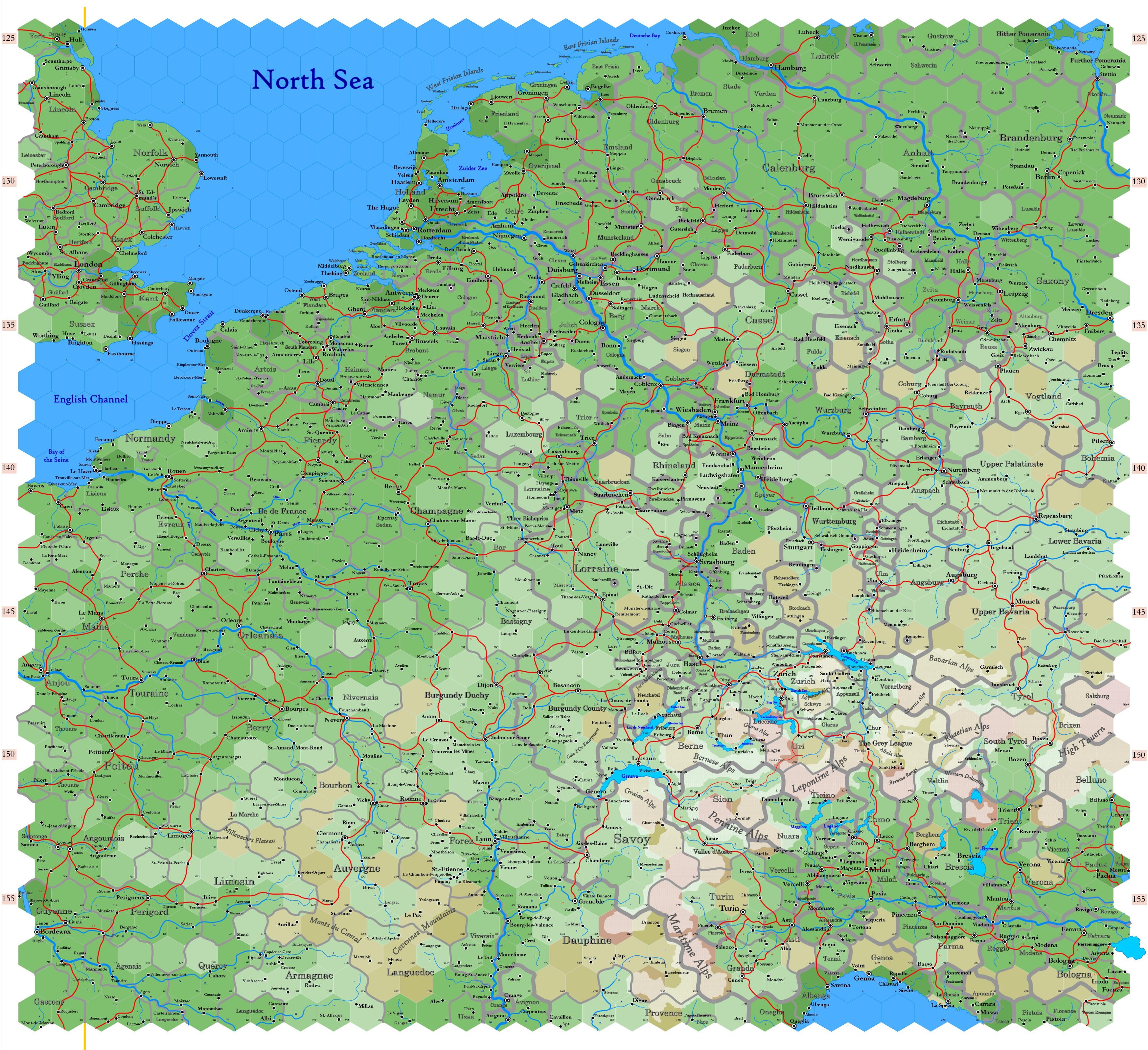
20-mile hexes are the standard unit for mapping large regions of the game world, referred to as sheet maps. Each hex spans 20 miles from side to side, covering an area of 346.41 square miles. The size matches detail with manageability; it is therefore possible to vast regions without overwhelming the map with excessive complexity. This is also practical for gameplay, as it aligns with travel distances that are easy to calculate and narratively significant. A day's journey on foot, horseback, or by other means fits neatly within or spans multiple hexes, making it intuitive for tracking progress and encounters. Furthermore, the hex system simplifies distance measurements, directions and regional relationships, which are critical when designing a game world for exploration and adventure.
The 20-mile hex is particularly well-suited for representing trade and travel because it aligns with the practical distance that can be covered in a day under favourable conditions. Over flat ground and on a reasonably maintained road, traders, merchants and travelers can comfortably traverse one hex on foot, horseback or by wagon, making it a natural unit for organizing trade routes and regional economies. This scale therefore allows for the logical placement of settlements, markets and waypoints within a game world. as well as the measurement of shipping routes, which can represent enormous distances.
Area measurements for national districts are typically expressed in hexes rather than square miles, as it is easier for players to conceptualize an area consisting of seven 20-mile hexes than 2,422 square miles. For reference, seven 20-mile hexes encompasses an area slightly smaller than the U.S. state of Delaware or the British entity of Devonshire.
Subdivision into Smaller Hexes
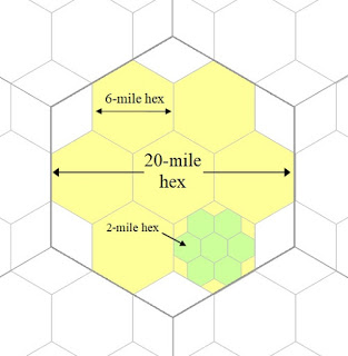
These hexes can be subdivided into 6-mile hexes and 2-mile hexes, as illustrated in the diagram below. This subdivision allows for greater detail in specific regions when needed. A single 20-mile hex is large enough to represent expansive terrain with general features, such as forests, mountain ranges or cities. However, for gameplay that demands precision — such as detailed exploration, tactical movement or placing smaller landmarks — the hex can be divided into smaller, more manageable units.
Despite their names, 6-mile hexes actually measure 6.67 miles across, while 2-mile hexes measure 2.22 miles. The simplified names make these scales easier to reference during gameplay, though accurate dimensions are recorded for precise mapping purposes. A 6-mile hex is particularly useful for representing individual towns, smaller natural features like lakes or hills and local travel routes. It aligns well with the idea of shorter travel segments, as 6 miles is roughly the distance one can walk in a few hours.
A 2-mile hex provides even finer resolution, ideal for mapping individual villages, small clusters of farms or other localised features. This scale is also perfect for representing detailed environments where tactical play or exploration is taking place, such as the surroundings of a dungeon, a battlefield or a densely populated settlement.
The ability to shift between these scales means that DMs can maintain a cohesive map at a broader level while offering the precision needed for specific regions without losing consistency. This hierarchical system keeps the world map manageable while still accommodating the intricacies of gameplay when the party moves into a smaller area.
Mapping Trade Routes
Because the world is simply enormous, while trade routes must be determined between locations that are thousands of miles apart, the use of a 20-mile hex simplifies the visualisation of these vast distances. Trade routes naturally follow paths of least resistance, such as flat terrain, rivers or established roads, and the 20-mile hex allows for the clear plotting of these routes on a global scale without overwhelming detail. Each hex can represent a day's travel under ideal conditions, making it easier to calculate the progression of goods and caravans across continents.
This allows for a clear depiction of major trade arteries that connect distant cities, ports and regions. A trade route that spans hundreds or thousands of miles can be broken down into a series of hexes, each representing a meaningful portion of the journey. This approach makes it possible to track the flow of goods and resources between points of production and distribution while maintaining a broad perspective of the overall network.
Furthermore, the 20-mile hex offers an intuitive way to represent strategic chokepoints and hubs along these routes, such as mountain passes, river crossings or vital crossroads. Controlling a few critical hexes along a trade route could determine the economic fortunes of a region or serve as the basis for conflicts over trade monopolies, tolls or territorial control. By structuring the world's trade system around 20-mile hexes, the immense scale of global commerce becomes comprehensible and playable, without losing the sense of distance and effort required for long-distance trade.
See also,
Map Scales
Trade Route Maps

