|
|
| Line 1: |
Line 1: |
| − | [[File:B.02 - Lapland.png|680px|thumb]] | + | [[File:B.02 - Lapland.jpg|right|680px|thumb]] |
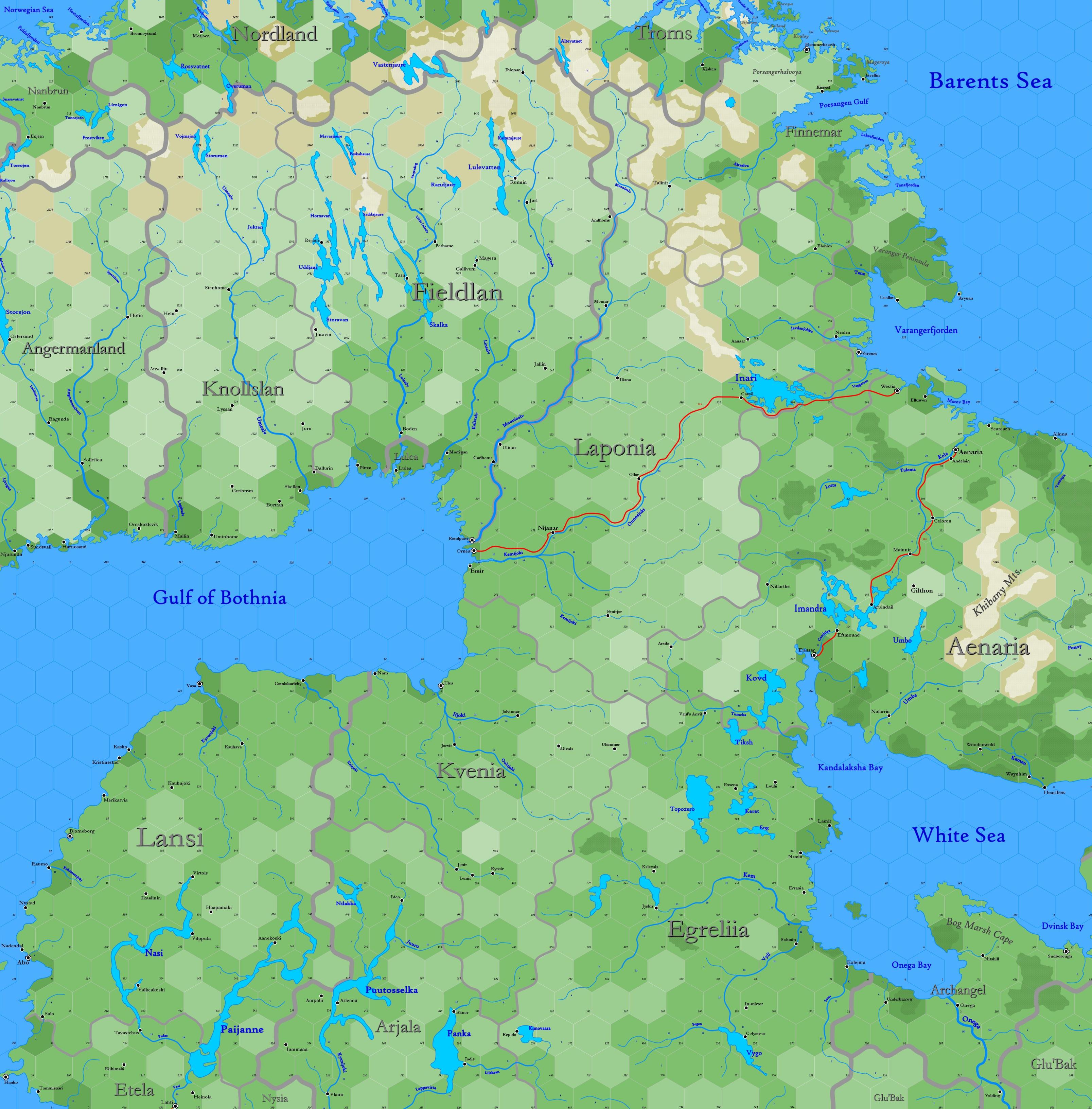
| − | | + | Sub-arctic region reaching from 77.22°N south to 62.96°N |
| − | Click to enlarge. Shows latitude 62.96° to 72.50° north; shows longitude at bottom of map between 14.19°E to 41.28°E. The orange line through the map indicates 30°E. Hexes are [[20-mile Hex Map|20 miles]] in diameter. Numbers at the right indicate distance from the north pole in hexes; the direction of north is at the top right, so it must be noted the direction on the map turns 60° at the 30th meridian.
| |
| − | | |
| − | == Land ==
| |
| − | The map depicts the whole of [[County of Archangel|Archangel]] and [[Kingdom of Vastenjaur|Vastenjaur]] ([[Earldom of Fieldland|Fieldland]], [[Earldom of Knollslan|Knollslan]]), with parts of [[Kingdom of Bjarmaland|Bjarmaland]] ([[Barony of Glu'Bak|Glu'Bak]]), [[Kingdom of Denmark & Norway|Norway]] ([[County of Nordland|Nordland]], [[County of Troms|Troms]]), [[Thane of Nanbrun|Nanbrun]], [[Kingdom of Sweden|Sweden]] ([[County of Angermanland|Angermanland]], [[Duchy of Etela|Etela]], [[Duchy of Lansi|Lansi]], [[County of Nysia|Nysia]]) and [[Principality of Ulthua|Ulthua]] ([[Great Thann of Aenaria|Aenaria]], [[Thann of Arjala|Arjala]], [[Thann of Egreliia|Egreliia]], [[Thann of Finnemar|Finnemar]], [[Thann of Kvenia|Kvenia]], [[Thann of Laponia|Laponia]]). The Gulf of Bothnia and the White Sea, as well as the coast of the Barents Sea, are frozen for many months of the year.
| |
| − | | |
| − | == Peoples ==
| |
| − | The map includes [[Gnome Race & Physiology|gnomish]] populations in Fieldland, Knollslan and Nanbrun; an [[Elf Race & Physiology|elvish]] population in Aenaria, Arjala, Egreliia, Finnemar, Kvenia and Laponia; a [[Halfling Race & Physiology|halfling]] population in Archangel; [[Human Race & Physiology|human]] populations in Angermanland, Etela, Lansi, Nordland, Nysia and Troms; and [[Gnoll|gnoll]] populations in Glu'Bak. Parts of the Scandinavian mountains at the top of the map are known to be occupied by stone giants.
| |
| − | | |
| − | Historically, numerous wars have been waged between Sweden and Ulthua, though there have been no formal hostilities in more than a century. Raids upon Archangel and Egreliia by gnolls take place to this day. Regardless, a significant trade in timber and other raw materials is shipped through the Gulf of Bothnia from Randparn, Lulea, Ulea and Vasa to greater ports throughout the Baltic Sea. During the summer, Archangel is the most important port in northern Europe, having access to valuable furs and rare metals from distant Moscovy and the Ural Mountains.
| |
| − | <br>
| |
| − | <br>
| |
| − | See Also,<br>
| |
| − | [[Sheet Maps]]<br>
| |
| − | :East: [[Map B.03 - Yak'Margug|Yak'Margug]]<br>
| |
| − | :NEast: [[Map A.02 - East Svalbard|East Svalbard]]<br>
| |
| − | :NWest: [[Map A.01 - Greenland Sea|Greenland Sea]]<br>
| |
| − | :West: [[Map B.01 - Lofoten|Lofoten]]<br>
| |
| − | <br>
| |
| − | And from Wikipedia:<br>
| |
| − | :[https://en.wikipedia.org/wiki/Arkhangelsk Arkhangelsk] / [https://en.wikipedia.org/wiki/Finland Finland] / [https://en.wikipedia.org/wiki/Karelia Karelia] / [https://en.wikipedia.org/wiki/Murmansk_Oblast Murmansk] / [https://en.wikipedia.org/wiki/Norway Norway] / [https://en.wikipedia.org/wiki/Sweden Sweden]
| |
